



You know, maybe Marco Rubio’s State Department should spend a little less time prissing at longtime allies who dare to suggest that our credibility on human rights is fully shot, and a little less time humping Nazi parties in Europe, and a little more time looking at a fucking map of the earth.
This is so embarrassing, you are going to die, this is one of those moments where you are going to die of embarrassment for what a clown country the United States of America has become.

Marco Rubio’s State Department marched its too-big Florsheims down to Brazil for an AIDS conference, which is weird because Elon Musk’s woodchippering of USAID and the rest of the Trump regime’s cuts to AIDS funding, not to mention its obsession with forcing any remaining recipients to comply with Trump’s bigoted, inbred anti-DEI rules, is likely already killing people with AIDS all over the world.
(To be fair, the Guardian notes that PEPFAR’s main work has “largely resumed” after initial Trump pauses, but this brand new study says PEPFAR disruptions “hobbled global HIV care.” Also to be fair, that Guardian link doesn’t say “kill” or “die,” we are just sloppily extrapolating what happens when poor people who were getting HIV/AIDS treatment suddenly can’t get it anymore, or if it suddenly “pauses” without explanation. For fairness’s sake, perhaps we should simply say the Trump regime is Making AIDS Great Again. Here’s more about how Trump and Elon Musk and Marco Rubio are Making AIDS Great Again, especially for kids.)
In the course of their presentation, the US used this map, which was obtained by Reuters and is now going viral (definition of fair use):
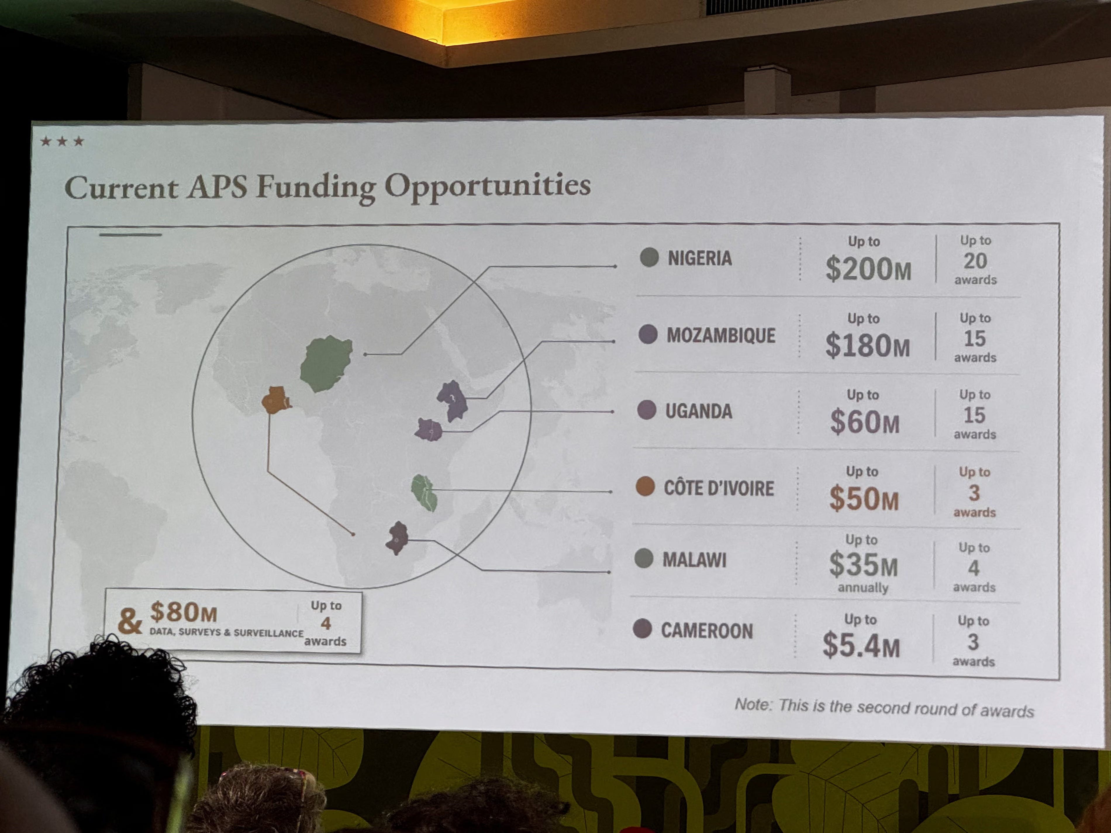
What’s awesome about that map is that Africa is on it, which is good, because they were intending to talk about Africa.
And the correct answers ended there.
One incredible thing about that map is that the countries it purports to list are not even shaped like that (we know, we are looking at Google Maps as we write this, because we are a JOURNALISM SCIENTIST), nor are the countries that are actually in those spots shaped like that.
That’s right. They’re all shaped wrong, and they’re also wrong in all the other ways of geographical wrongness.
Is that Nigeria? Noooooo, the country right there isn’t shaped like that, but it’s called Niger. (We understand that at the Trump State Department those country names likely send viewers into paroxysms of rage over NO FAIR! WHAH THEY GET TO SAY IT AND I CAIN’T?)
Where is Nigeria? Directly south of that.
Is that Mozambique? Nooooooo, the country right there isn’t shaped like that, but it is sort of where Ethiopia is, maybe a little bit of South Sudan.
Where is Mozambique? Waaaaay down south, same coast, facing Madagascar.
Is that Uganda? Noooooooo, but that’s probably the closest. It’s not shaped like that, but it’s approximately there.
Is that Côte D’Ivoire? We dunno, dumbass, what the fuck does “Côte” mean? Does it mean “inland country that’s not shaped like that next to where we should have fucking put Mozambique on this goddamned map”?
Where is Côte D’Ivoire? Right about where they put “Cameroon,” but that’s the one where the pointer line gets lost and goes nowhere, so who the fuck knows.
Cameroon is just east of and heading down and around the coast from Nigeria. The real one, not the Little Marco State Department Nigeria.
Which brings us to Malawi. Is that Malawi? Noooooooo, the country/ies there aren’t shaped like that, but that appears to be a bit of Botswana, a bit of Zimbabwe.
Where is Malawi? Maybe Marco Rubio should call Madonna’s children and fucking find out.
And this is what happens when you use Open AI to make your map for the conference about all the non-white people you’re leaving alone with their AIDS.
It’s also what happens when your State Department has been hollowed out of all experts, all diplomats, all geography geeks who do nothing but stare at maps all day, and replace them with incel Nazi buffoons and racist human garbage. At literally any other president’s State Department, scores of people would have immediately seen this map — even if they were using AI to help them make their reports! — and immediately said, “Yeah that map is not correct. Learn a fucking map, AI robot!”
But this is the Trump administration, where the racism is only matched by the stupidity of every single one of their homeschooled loser hires. We would say maybe they would’ve done better if they were working with a continent they and their Dear Leader don’t believe is full of “shithole countries,” but honestly, we don’t think they’d do any better with Europe.
“Whoever created and approved this slide did not know where countries in Africa are and did not care to check their work,” wrote Matt Petit, who focuses on AI and geopolitics at the Atlantic Council, in [a post on LinkedIn that received 40,000 views].
The State Department says it’s sorry, “We take full responsibility for the confusion and misrepresentation it caused for attendees, including our African partners,” it was an underling who did it, oh boy, how embarrassing.
Fuck them, apology not accepted, go to prison and take a fucking globe with you, you absolute morons.
[Guardian]
Want to read more Evan than just what’s at Wonkette? Visit The Moral High Ground and subscribe to it!
Follow me on Instagram!
Subscribe to me on YouTube!
And on BlueSky!
And on Facebook!
All of that is incredible, but to make Ivory COAST a LANDLOCKED country is special.
Just because OpenAI can't produce an accurate map of Africa from readily available and searchable sources doesn't mean it shouldn't get hundreds of billions of investment.